


 Zone - (NW)
The Kano-Katsina road route A9 is 152.655km length starting from Dawanau Roundabout (Miltara) in Kano and ends in Steel Rolling Roundabout, ...
Zone - (NW)
The road has an ongoing project awarded to M/s BUA International Ltd with contract sum of N115,425,896,907.15 under the Federal Government’s Road Infrastructure Development and Refurbishment Tax Credit Scheme. Percentage completion is 1.54%
Zone - (NW)
The Zaria-Funtua Road is a very important route used for evacuation of produce and provides access to the educational city of Zaria. The road traverses through Kaduna and Katsina States in the Northwest Geopolitical zone of Nigeria. The total length of the road is 47Km and begins from Shika bridge ...
Zone - (NW)
The Funtua-Sokoto Road is a very important route for agricultural and industrial purpose. The road traverses through Katsina, Zamfara and Sokoto States in the Northwest Geopolitical zone of Nigeria. The total length of the road is 315.33Km and begins at Funtua roundabout in Katsina State (Ch 0+000; Coordinates N11°30'05.3'', E7°19'01.9'') ...
Zone - (NW)
The road is part of the Apapa – Ilorin – Kontagora - Sokoto road (A.1) that is a very important road connecting the Southwest to Northwest geopolitical zones and Niger Republic. The road is very vital in the socio-economic relationship between communities along the route and Niger Republic. The ...
Zone - (NE)
The Gombe - Biu Road (route F.129) traverses through Borno and Gombe States. The total length of the road is 126 Km starting from Gombeline Motorpark, Gombe (Ch 0+000; Coordinates N10°17’14’’, E 11°9’55’’) and terminating at Biu Township Roundabout, Borno State (Ch 126+000; Coordinates N 10°36’59’’, E 12°11’31’’). It ...
Zone - (NE)
The Biu – Numan Road, Route 90(A4) traverses through Borno and Adamawa States. The total length of the road is 139 Km starting from the Nigerian Army University first gate in Biu (Ch 0+000; Coordinates N10°37’16’’, E 12°9’42’’) and terminating at Ngwalam town near Numan in Adamawa State (Ch 139+000; ...
Zone - (NE)
The Numan – Jalingo Road, Route (A.4) traverses through Adamawa and Taraba States. The total length of the road is 103.559 Km starting from Numan Roundabout, Adamawa State (Ch 0+000; Coordinates lat 9.470237, long 12.034795) and terminating at Jalingo Roundabout (Ch 103+559; Coordinates lat 8.957594, long 11.367911). The road passes ...
Zone - (NE)
The Yola – Gombe Road, Route (A.345) traverses through Adamawa, Borno and Gombe States. The total length of the road is 235 Km starting from Mai-doki Roundabout, Yola (Ch 0+000; Coordinates lat 9.2775030, long 12.4243860) and terminating at Gombeline Roundabout (Ch 235+000; Coordinates ...
Zone - (NE)
The road is part of the Federal Road on the A3 highway, that runs across Nigeria diagonally from Port Harcourt via Makurdi to Akwanga, then to Jos connecting Bauchi to Kari and onwards to Potiskum, Damaturu and finally to Borno Sate. The road traverses through Bauchi and Yobe States. The ...
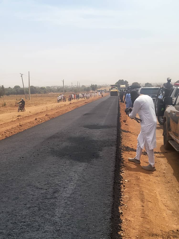

The Kano-Katsina road route A9 is 152.655km length starting from Dawanau Roundabout (Miltara) in Kano and ends in Steel Rolling Roundabout, Katsina State. The road is currently undergoing dualization which involves construction of additional carriageway and the reconstruction of the existing one. For the new carriageway, works already begun since July, 2020. The cross section of the road is four lanes, two expressways. One lane is 11.55m which includes 7.3 carriageway, 2.75m and 1.5m outer and inner shoulders respectively. The coordinates of the starting point at Ch0+000 Kano State Border) is 12004’46’’N 8027’01’’E, while the end point is at Ch152+655 12057’48’’N, 7037’38’’E (Steel Rolling Roundabout). The road is part of the Federal Road on the A9 highway that runs from Kano-Bichi-Katsina-Jibiya (Niger Border with Katsina) and to the junction with Trunk Road A.2 in Katsina State. The road condition survey with schematic drawings are attached as Annex I and Annex II respectively for each state.
The road has an ongoing project awarded to M/s BUA International Ltd with contract sum of N115,425,896,907.15 under the Federal Government’s Road Infrastructure Development and Refurbishment Tax Credit Scheme. Percentage completion is 1.54%
The Zaria-Funtua Road is a very important route used for evacuation of produce and provides access to the educational city of Zaria. The road traverses through Kaduna and Katsina States in the Northwest Geopolitical zone of Nigeria. The total length of the road is 47Km and begins from Shika bridge in Zaria (Ch0+000; coordinates N11° 11' 46.4'', E 7° 34' 26.1'') and terminates at Funtua roundabout in Katsina State (Ch 47+000; Coordinates N11° 30' 05.3'', E 7° 19' 01.9''). Notable towns along the route include Zaria, Giwa, Faskari and Funtua.
The Funtua-Sokoto Road is a very important route for agricultural and industrial purpose. The road traverses through Katsina, Zamfara and Sokoto States in the Northwest Geopolitical zone of Nigeria. The total length of the road is 315.33Km and begins at Funtua roundabout in Katsina State (Ch 0+000; Coordinates N11°30'05.3'', E7°19'01.9'') and ends at Damboa Roundabout, Sokoto (Ch 315 +000; Coordinates N13°0'17.87'', E 5°15'1.49''). Notable towns along the route include Funtua, Kotorkoshi, Gusau, Tsafe, Maru, Bungudu, Talata Mafara, Dange and Sokoto.
The road is part of the Apapa – Ilorin – Kontagora - Sokoto road (A.1) that is a very important road connecting the Southwest to Northwest geopolitical zones and Niger Republic. The road is very vital in the socio-economic relationship between communities along the route and Niger Republic. The road begins from Sokoto water board roundabout (Ch 0+000; Coordinates 1304’32’’N, 50 5’22”E) and ends at the border between Nigeria & Niger republic (Ch 87+000; Coordinates 13045’20’’N, 50 16’5”E), covering a total distance of 87Km. The major towns along the road are Kware and Gwadabawa.
The Gombe - Biu Road (route F.129) traverses through Borno and Gombe States. The total length of the road is 126 Km starting from Gombeline Motorpark, Gombe (Ch 0+000; Coordinates N10°17’14’’, E 11°9’55’’) and terminating at Biu Township Roundabout, Borno State (Ch 126+000; Coordinates N 10°36’59’’, E 12°11’31’’). It traverses through several towns/villages and vast farmlands along the road corridor, these include; Kwadom, Kanawa, Baure, Dadin–Kowa, Jauro shehu, Bayo, Wuyo, Kwaya-Kusar, Wandali, Tashan Gauta, Vinadam and Biu Town.
The Biu – Numan Road, Route 90(A4) traverses through Borno and Adamawa States. The total length of the road is 139 Km starting from the Nigerian Army University first gate in Biu (Ch 0+000; Coordinates N10°37’16’’, E 12°9’42’’) and terminating at Ngwalam town near Numan in Adamawa State (Ch 139+000; Coordinates N 9°31’20’’, E 12°0’56’’). The road passes through rich agricultural towns like Biu, Marama, Bulatawiwi, Gusi, Milda, Shani, Bargu, Guyuk, Shelleng, kiri Dam, Savanna Sugar company ( now Dangote sugar company) terminating at Ngwalam town, intersecting Gombe - Cham - Numan road.
The Numan – Jalingo Road, Route (A.4) traverses through Adamawa and Taraba States. The total length of the road is 103.559 Km starting from Numan Roundabout, Adamawa State (Ch 0+000; Coordinates lat 9.470237, long 12.034795) and terminating at Jalingo Roundabout (Ch 103+559; Coordinates lat 8.957594, long 11.367911). The road passes through towns like Kada, Bali, Jimleri, Mayolope, and Maraba Zing amongst others.
The Yola – Gombe Road, Route (A.345) traverses through Adamawa, Borno and Gombe States. The total length of the road is 235 Km starting from Mai-doki Roundabout, Yola (Ch 0+000; Coordinates lat 9.2775030, long 12.4243860) and terminating at Gombeline Roundabout (Ch 235+000; Coordinates lat 10.2870980, long 11.1664980). The road passes through towns like Ngurore, Numan, Lafiya, Cham, Kaltungo, Biliri, and Kumo amongst others.
The road is part of the Federal Road on the A3 highway, that runs across Nigeria diagonally from Port Harcourt via Makurdi to Akwanga, then to Jos connecting Bauchi to Kari and onwards to Potiskum, Damaturu and finally to Borno Sate. The road traverses through Bauchi and Yobe States. The total length of the road is 220.7Km starting from Hawan Malka Roundabout, Potiskum (Ch 0+000; Coordinates lat 11.695486, long 11.908322) and terminates at Gidan Mai Roundabout, Bauchi (lat 11.45272816, long 10.90212781) . Notable towns along the road include Dagare, Kukar Gadu, Kari, Darazo, Soro among others.