


 Zone - (NW/NE)
The Shuarin–Azare Road is part of the Federal Road on Route F.130 that runs from the Northwest to the Northeast via Jigawa and Bauchi States. The total length of the road is 87.4Km starting from Shuarin Bridge in Jigawa State (Ch 0+000; Coordinates N11°47’02’’, E 9°24’23’’) and terminating at ...
Zone - (NC)
The Suleja - Minna Road (Route A.124/F.126) route is an important route linking part of North Central and North West zone of the Country to the Federal Capital Territory. The road links to Abuja - Kaduna Highway(A2) and also links the Trans Sahara Highway route A1 at (Mokwa). The total length ...
Zone - (NC/SS)
The Lokoja–Benin Road is part of Route A.2 that is the major road connecting the North with the South of Nigeria. The road traverses through Kogi and Edo States in North Central and South South Nigeria. The total length of the road is 241.5 Km starting from Kabba Junction/Obajana Road ...
Zone - (NC)
The Ilorin -Jebba road is 107.2km in length. The road starts from Oyo State Boundary,Otte (CH.0+000; Coordinates lat 8.3165640 and long 4.3772710 and) and ends at Jebba bridge/Niger State boundary (Ch 107+200; Coordinates long 4.8121640 and lat 9.1389510). The Ilorin – Jebba road is part of Route A.1 which ...
Zone - (NC)
The Minna - Zungeru road (Route F.126) is one of the major routes used in transporting industrial and agricultural products . The road is 58.4Km in length and starts from Mobil Roundabout Minna (Ch 0+000; Coordinates 230810.5794E, 1063740.9228N ) and terminates at Zungeru Bridge (Ch 58+400; Coordinates 188522.262E, 1085884.365N). It ...
Zone - (SW)
The Ibadan-Oyo-Ogbomosho-Ilorin road is an important route that links the western part of Nigeria to the Northern States. The road begins from Ojoo in Ibadan, Oyo State (Ch 0+000; Coordinates lat 7.465525o and long 3.91526o) and terminates at the boundary between Oyo and Kwara States (Otte) ...
Zone - (SW)
The Ibadan-Ife-Ilesha road is an integral part of the Ibadan-Akure-Benin Federal Highway . The road traverses Oyo and Osun States and has a total length of 108.4Km starting from Iwo road roundabout, Ibadan (Ch 0+000; Coordinates lat 7.4028800, long 3.94448160) and terminating at Iwaraja Junction in Ilesha (Ch 108+400; Coordinates ...
Zone - (SW)
The Ilesha - Akure – Owo road (A.122) is an important highway that traverses through Osun and Ondo States in Southwest Nigeria. The road starts at Iwaraja Junction, Ilesha in Osun State (Coordinates N 7.62, E4.82) and continues through the boundary between Osun and Ondo States (Owena) and terminates ...
Zone - (SW)
DESCRIPTION / PHYSICAL CONDITION SURVEY OF IBADAN- ABEOKUTA RD The Ibadan-Abeokuta Road, Route (E.1) traverses through Oyo and Ogun States in Southwest Nigeria. The total length of the road is 72.7 Km starting from the Zenith Bank, Dugbe, Ibadan (Ch 0+000; Coordinates N7.387605, ...
Zone - (SW)
The Akure – Ado Ekiti road Route F.209 in Ondo/Ekiti States is an important highway in the South-West geopolitical zone in Nigeria. It links Ondo state to Ekiti state and other parts of the country thereby serving as a very vital and important major axis. The total length of the ...
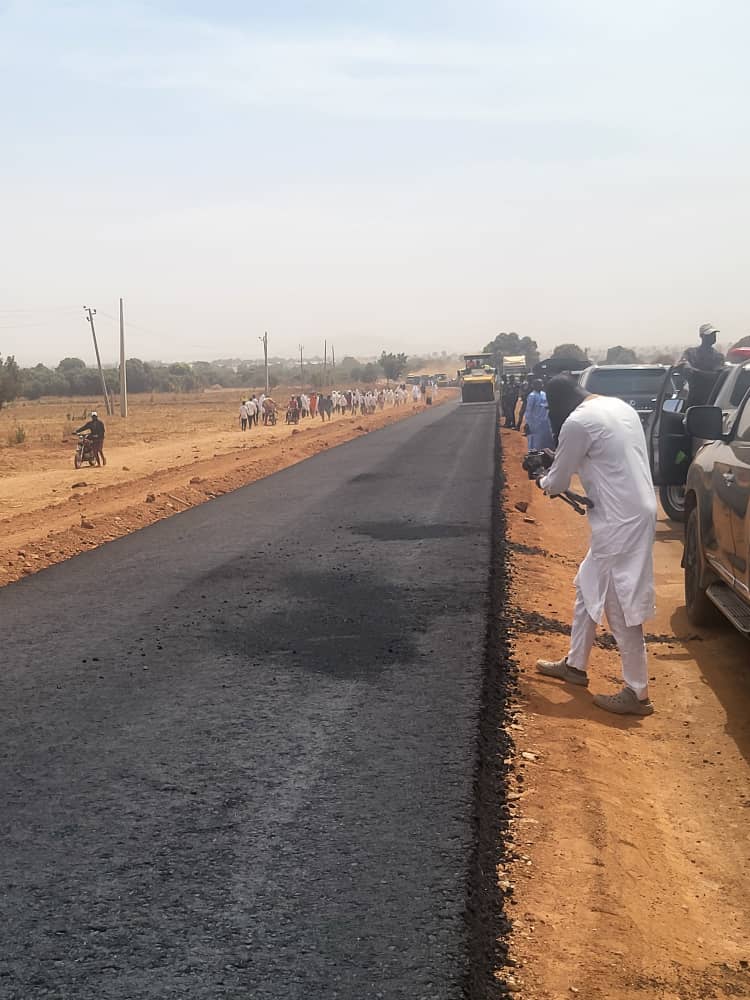

The Shuarin–Azare Road is part of the Federal Road on Route F.130 that runs from the Northwest to the Northeast via Jigawa and Bauchi States. The total length of the road is 87.4Km starting from Shuarin Bridge in Jigawa State (Ch 0+000; Coordinates N11°47’02’’, E 9°24’23’’) and terminating at First bypass roundabout Azare, Bauchi State (Ch 87+400; Coordinates N 11°40’23.47’’, E 10°8’35.10’’). The road passes through such towns/settlements as Kiyawa, Andaza, Talba, Jama’are,and Galadamari .
The Suleja - Minna Road (Route A.124/F.126) route is an important route linking part of North Central and North West zone of the Country to the Federal Capital Territory. The road links to Abuja - Kaduna Highway(A2) and also links the Trans Sahara Highway route A1 at (Mokwa). The total length of the road is 101Km. The road starts at Diko Junction (Ch +000; Coordinates 304260.3E, 1025480.4N) and terminates at Minna City Gate (Ch 101+000; Coordinates 234423.2E, 1055360.2N). The increase in vehicular traffic along the alignment made it necessary to dualize the road such that the new asphaltic paved road will cater for the load characteristics of the vehicles plying the road.
The Lokoja–Benin Road is part of Route A.2 that is the major road connecting the North with the South of Nigeria. The road traverses through Kogi and Edo States in North Central and South South Nigeria. The total length of the road is 241.5 Km starting from Kabba Junction/Obajana Road in Kogi State (Ch 0+000; Coordinates N 7.824908, E 6.585122) and terminating at Ramat Park in Benin City (Ch 241+500; Coordinates N 6.350611, E 5.661167). The road passes through towns such as Adankolo, Itakpe, Okene, Okpella, Auchi, Ekpoma, Iruekpen, and Ehor amongst others.
The Ilorin -Jebba road is 107.2km in length. The road starts from Oyo State Boundary,Otte (CH.0+000; Coordinates lat 8.3165640 and long 4.3772710 and) and ends at Jebba bridge/Niger State boundary (Ch 107+200; Coordinates long 4.8121640 and lat 9.1389510). The Ilorin – Jebba road is part of Route A.1 which serves as a major agricultural and industrial route linking the South-West, North Central and North- West Geopolitical zones.
The Minna - Zungeru road (Route F.126) is one of the major routes used in transporting industrial and agricultural products . The road is 58.4Km in length and starts from Mobil Roundabout Minna (Ch 0+000; Coordinates 230810.5794E, 1063740.9228N ) and terminates at Zungeru Bridge (Ch 58+400; Coordinates 188522.262E, 1085884.365N). It passes through towns and villages such as Maikonlele, Kuyi, Gusase, Jigbeji, Tundun Wada, Kodo, Kaliko and terminates at Zungeru which is the beginning of Zungeru - Kotangora road.
The Ibadan-Oyo-Ogbomosho-Ilorin road is an important route that links the western part of Nigeria to the Northern States. The road begins from Ojoo in Ibadan, Oyo State (Ch 0+000; Coordinates lat 7.465525o and long 3.91526o) and terminates at the boundary between Oyo and Kwara States (Otte) (Ch 120+100; Coordinates lat 8.316564o and long 4.37727o. Notable towns along the route include Ibadan,Oyo, Ogbomosho and Otte.
The Ibadan-Ife-Ilesha road is an integral part of the Ibadan-Akure-Benin Federal Highway . The road traverses Oyo and Osun States and has a total length of 108.4Km starting from Iwo road roundabout, Ibadan (Ch 0+000; Coordinates lat 7.4028800, long 3.94448160) and terminating at Iwaraja Junction in Ilesha (Ch 108+400; Coordinates lat 7.620, long 4.820). Notable towns along the road include Adegbayi, Asejire, Ikire, Wasimi, Majeroku, Gbongan, Ife, Osu and Ilesha.
The Ilesha - Akure – Owo road (A.122) is an important highway that traverses through Osun and Ondo States in Southwest Nigeria. The road starts at Iwaraja Junction, Ilesha in Osun State (Coordinates N 7.62, E4.82) and continues through the boundary between Osun and Ondo States (Owena) and terminates at Owo in Ondo State (Coordinates N 7.194301, E5.591366). The total length of the road is 113.1Km. The Ondo State section of the Ilesha – Akure - Owo Road is 76km in length, it commences at Owena (Osun State Boundary) 7.204315, 5.036244 and terminates at Owo 7.194301, 5.591366. The road is a single carriageway and is currently in fair condition. It is a very important federal road linking Ondo and Osun States to the Federal Capital territory, Abuja and other parts of Nigeria. The existing road consists of a single carriageway of 7.3m width and 2.75m shoulders on either sides, and the existing pavement structure is 200mm lateritic sub-base and 200mm stone-base, 60mm asphaltic concrete binder course and 40mm asphaltic concrete wearing course.
DESCRIPTION / PHYSICAL CONDITION SURVEY OF IBADAN- ABEOKUTA RD The Ibadan-Abeokuta Road, Route (E.1) traverses through Oyo and Ogun States in Southwest Nigeria. The total length of the road is 72.7 Km starting from the Zenith Bank, Dugbe, Ibadan (Ch 0+000; Coordinates N7.387605, E 3.876373) and terminating at Abiola Way Junction Abeokuta (Ch 72+700; Coordinates N 7.1722, E 3.3705849). Notable towns along the route include Omi Adio, Elesa, Bakari, Ilugun, Apitipiti, Otere,and Olodo,
The Akure – Ado Ekiti road Route F.209 in Ondo/Ekiti States is an important highway in the South-West geopolitical zone in Nigeria. It links Ondo state to Ekiti state and other parts of the country thereby serving as a very vital and important major axis. The total length of the road is 41.70Km. The road commences at Total Petrol Station, Ado Garage, Akure (N 7.281685, E 5.220449) and ends at Mobil Petrol Station Ajilosun, Ado-Ekiti (N7.616843, E5.223740).