


 Zone - (SE/SS)
The Enugu-Abakaliki-Ogoja road is a 197km highway. The road traverses through Enugu, Ebonyi and Cross-River States starting from CH.0+000 by Flyover at Naira Triangle, Airport Junction (GPS 6’458’’, 7’554’’) and terminates at CH.197+000 by end of Ogoja ((GPS 6’6620’’, 8’8304’’). The Enugu – Abakaliki - Ogoja road is part of Route ...
Zone - (SE)
BRIEF DESCRIPTION / PHYSICAL CONDITION SURVEY The Afikpo-Okigwe Road is part of Route No. F112 which serves as a major link between the South-East and parts of South-South Geopolitical Zones. Most of the road is in fairly good condition. The Afikpo-Okigwe road is a 76.4km road starting from Afikpo Junction ...
Zone - (SE)
DESCRIPTION / PHYSICAL CONDITION SURVEY OF OBA- NNEWI- OKIGWE RD The Oba-Nnewi-Okigwe Road (Route F.112) traverses Anambra and Imo States in South East Nigeria. The total length of the road is 72.350 Km starting from Oba Junction (Ch 0+000; UTM Coordinates 258284.946 E, 670984.217 N) and terminating at Okigwe Junction in ...
Zone - (SS)
The Benin - Sapele - Warri road is a major connection between Warri Sea port and Benin City that traverses through Edo and Delta States to South-West, Nigeria. It is also part of the Trunk Route A2 that connects Port Harcourt seaport in South-South Zone to Kano North-West Zone. The ...
Zone - (SS)
The Warri-Eleme Junction Road which is part of the East West road is a major Federal arterial route, which runs from Warri through Kaiama, to Eleme Junction in Rivers State. The road links Lagos through Benin, Ore, Sagamu and has great influence on socio-economic activities in the South-South geopolitical zone ...
Zone - (SS)
BRIEF DESCRIPTION/ ROAD CONDITION SURVEY OF ELEME JUNCTION -EKET- ORON RD The Eleme Junction-Eket-Oron Road (Route F.103) is part of the East-West Road which is a major arterial Highway. The road traverses through Rivers and Akwa Ibom States. The total length of the road is 149.7Km starting from Eleme Junction (Ch ...
Zone - (SE/SS)
The Aba -Ikot Ekpene road is 36.825km in length. The road alignment lies within Aba and Ikot Ekpene areas of Abia and Akwa Ibom States. It falls within the built up semi-urban areas of the two states, starting from Opopo junction, Aba (CH.0+000) to Ikot Ekpene Plaza/Motor Park, (CH.36+825). The ...
Zone - (SS)
The Odukpani-Itu-Ikot Ekpene Road (Route A.4-1) traverses through Cross River and Akwa Ibom States in the South-South geopolitical zone of Nigeria. The total length of the road is 87.5 Km starting from Tinapa Junction in Cross River State (Ch 0+000; Coordinates N 5.15528, E 8.34640) and terminating at Ibiakpan ...
Zone - (NC)
The Akwanga-Jos-Bauchi Road (Route A.3) is part of the Federal Road Route A.3 that connects the South South, South East, North Central to the North East Geopolitical Zones of Nigeria. The road traverses through Nassarawa, Kaduna, Plateau and Bauchi States. The total length of the road is 290.5Km starting from ...
Zone - (SE)
BRIEF DESCRIPTION / PHYSICAL CONDITION SURVEY ENUGU- ONITSHA RD The Enugu-Onitsha Road (Route A.232) is a dual carriageway with 7.3m asphaltic concrete surfacing and 2.75m outer shoulders and 1.8m inner shoulders. The road connects the South East and South South with Lagos, South West and the Northern parts of the ...
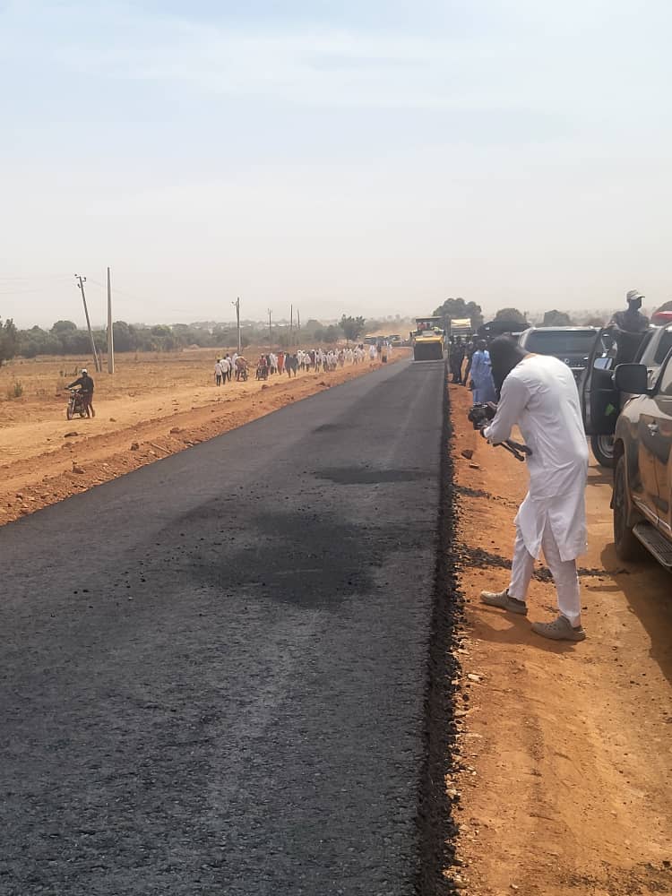

The Enugu-Abakaliki-Ogoja road is a 197km highway. The road traverses through Enugu, Ebonyi and Cross-River States starting from CH.0+000 by Flyover at Naira Triangle, Airport Junction (GPS 6’458’’, 7’554’’) and terminates at CH.197+000 by end of Ogoja ((GPS 6’6620’’, 8’8304’’). The Enugu – Abakaliki - Ogoja road is part of Route A.343/A.4 which serves as a major link between the South-East, the South-South and some parts of the Middle Belt zones of Nigeria. There is no existing contract on the afore-mentioned road because it has not been awarded yet.
BRIEF DESCRIPTION / PHYSICAL CONDITION SURVEY The Afikpo-Okigwe Road is part of Route No. F112 which serves as a major link between the South-East and parts of South-South Geopolitical Zones. Most of the road is in fairly good condition. The Afikpo-Okigwe road is a 76.4km road starting from Afikpo Junction in Ebonyi State (Ch.0+000; Coordinates lat 5.88290, long 7.93730) and terminates at Okigwe Round-about in Imo State (Ch.76+400; Coordinates lat 5.82880, long 7.39540). Notable towns along the road include Amasiri, Oso, Isieke, Akaeze, Anyaragu, Uturu, and Ihube.
DESCRIPTION / PHYSICAL CONDITION SURVEY OF OBA- NNEWI- OKIGWE RD The Oba-Nnewi-Okigwe Road (Route F.112) traverses Anambra and Imo States in South East Nigeria. The total length of the road is 72.350 Km starting from Oba Junction (Ch 0+000; UTM Coordinates 258284.946 E, 670984.217 N) and terminating at Okigwe Junction in Imo State (Ch 72+350; UTM Coordinates 316639.42 E, 647725.25 N). Some towns along the route include Amichi, Uga/Akokwa, Arondizuogu and Nnewi.
The Benin - Sapele - Warri road is a major connection between Warri Sea port and Benin City that traverses through Edo and Delta States to South-West, Nigeria. It is also part of the Trunk Route A2 that connects Port Harcourt seaport in South-South Zone to Kano North-West Zone. The road is 86.075Km in length beginning from Ring Road, Benin (Ch 0+000; Coordinates N 6019’55.1’’, E 50 37’23.1’’) and terminates at Effurun Roundabout , Delta State ( Ch 86+075; Coordinates N 5° 34' 27.8652'', E 5° 47' 1.2768'' ). Notable towns along the road include Obaretin, Imasabor, Ologbo, Oghara, Sapele, Elume, Opraja, and Okuovo.
The Warri-Eleme Junction Road which is part of the East West road is a major Federal arterial route, which runs from Warri through Kaiama, to Eleme Junction in Rivers State. The road links Lagos through Benin, Ore, Sagamu and has great influence on socio-economic activities in the South-South geopolitical zone of the Country. The road is also a major outlet for the transportation of petroleum products from Port Harcourt and Warri Refineries to other parts of the Country. Oil exploration and industrial activities in the coastal Niger Delta Region depend heavily on the Warri – Eleme Junction road for movement of equipment, goods and personnel. The road traverses through Delta, Bayelsa and Rivers States. The total length of the road is 189.1Km beginning from DSC Roundabout Warri (Ch 0+000; Coordinates N5°34’15.85’’, E 5°48’33.12’’) and terminating at Eleme Junction flyover in Rivers State (Ch 189+100; Coordinates N4°51’17.30’’, E 7°4’4.46’’). The road passes through towns like Patani, Ughelli, Kaiama, Uwheru, Mbiama and Ahoada among others.
BRIEF DESCRIPTION/ ROAD CONDITION SURVEY OF ELEME JUNCTION -EKET- ORON RD The Eleme Junction-Eket-Oron Road (Route F.103) is part of the East-West Road which is a major arterial Highway. The road traverses through Rivers and Akwa Ibom States. The total length of the road is 149.7Km starting from Eleme Junction (Ch 0+000; Coordinates 4051’19”.248N, 704’3”.498E”) and terminating at Uya Roundabout in Oron, Akwa Ibom State (Ch 149+700; Coordinates N4047’48.67”, E 8012’34.21”). Notable towns along the route include Elelenwo, Onne, Kalaoko, Ikot Abasi, Ikot Ubo, Eket and Oron.
The Aba -Ikot Ekpene road is 36.825km in length. The road alignment lies within Aba and Ikot Ekpene areas of Abia and Akwa Ibom States. It falls within the built up semi-urban areas of the two states, starting from Opopo junction, Aba (CH.0+000) to Ikot Ekpene Plaza/Motor Park, (CH.36+825). The road traverses through Alaoji, Ntigha, Umuafukwu, Ohanze, Umuokpo and Onitsha Ngwa in Ngwa local government of Abia State and Ikot Umoessien, Odoro Ikot, Uwa West, Ikot Osurua, Ifuho and Ikot Obongedong in Essien Udim and Ikot Ekpene Local Government Areas of Akwa Ibom State. Geographically, it is situated between co-ordinates 5.5250° North, 7.4922° East and 5°11’ North, 7°43’ 0’’ East.
The Odukpani-Itu-Ikot Ekpene Road (Route A.4-1) traverses through Cross River and Akwa Ibom States in the South-South geopolitical zone of Nigeria. The total length of the road is 87.5 Km starting from Tinapa Junction in Cross River State (Ch 0+000; Coordinates N 5.15528, E 8.34640) and terminating at Ibiakpan Roundabout in Akwa Ibom State (Ch 87+500; Coordinates N 5.159963, E 7.740037). The road passes through towns/settlements such as Ikot Okon, Ikot Nyong, Itu, Ayadeghe, Mbak, Ikot Akpan, Ibiaku and Otuep.
The Akwanga-Jos-Bauchi Road (Route A.3) is part of the Federal Road Route A.3 that connects the South South, South East, North Central to the North East Geopolitical Zones of Nigeria. The road traverses through Nassarawa, Kaduna, Plateau and Bauchi States. The total length of the road is 290.5Km starting from Akwanga Town Roundabout, Nassarawa State (Ch 0+000; Coordinates N8055’30.37”, E 8035’52.91”) and terminating at Gidan Mai Roundabout, Bauchi (Ch 290+500; Coordinates N10019’14.09”, E 9049’19.38”).Notable towns along the route include Buku, Wamba, Angwan Nungu,Fadan Kashi, Angwan Boka, Hawan Kigbo,Riyom,Mraban Jamaá, Tilden Fulani,Toro,Magama amongst others.
BRIEF DESCRIPTION / PHYSICAL CONDITION SURVEY ENUGU- ONITSHA RD The Enugu-Onitsha Road (Route A.232) is a dual carriageway with 7.3m asphaltic concrete surfacing and 2.75m outer shoulders and 1.8m inner shoulders. The road connects the South East and South South with Lagos, South West and the Northern parts of the country. The road traverses Enugu and Anambra States and has a total length of 106.850Km starting from Abakpa Junction in Enugu (lat 6.46523660, long 7.52176830) and terminates at Onitsha Headbridge (lat 6.1320410, long 6.7655120) Notable towns along the route include Umunya, Amawbia, Kwata, Amansea, Nkwo and Ezeagu.